
Not a Through Street
A careful look at a Chicago city map from the 1880s shows a curious detail which does not match the modern street grid: Sacramento Ave was not originally a through-street between Medill and Lyndale.
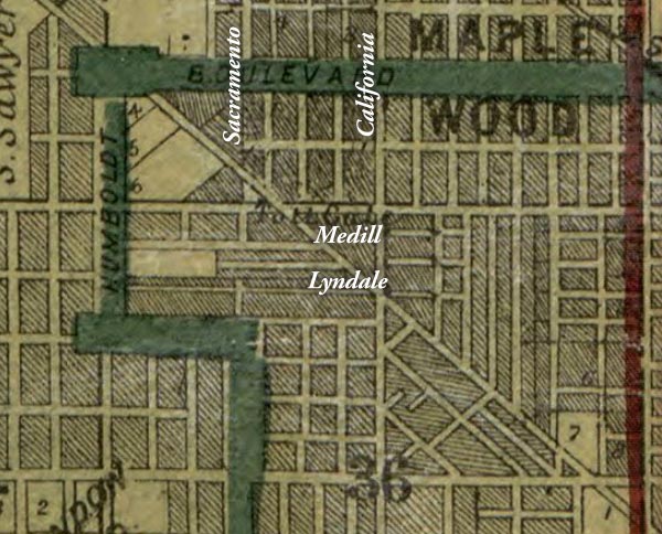
Detail of Snyder's real estate map of Cook County, Illinois, 1886 with modern street names added. Library of Congress, Geography and Map Division
At this time the Chicago city limits were at Western Avenue (the red vertical line in the detail of the 1886 map above). The Northwestern Plank Road which once ran across open prairie is still a toll road, but is now surrounded by newly-platted streets which were gradually being developed with new workers cottages and two-flats. The shaded areas of the map were subdivided, but may have only had a few houses. A few areas which appear lighter on the map remained as farm fields or undeveloped prairie.
In 1886 the wide boulevards were planned and laid out, though they would not be lined by grand houses and apartments for another fifteen or twenty years. At this time all of the zigzagging segments of the boulevard north of Humboldt Park were called Humboldt Boulevard. When the city standardized street addresses in 1909 these segments were given separate names as Palmer Square, Kedzie Boulevard and Logan Boulevard.
Just north Palmer Square are Lyndale and Belden streets. The north side of Lyndale had been divided into lots, but the west end of Belden just above it was still blank. On the map there is no connection between the two streets, making one very long block between them.
A different map from 1886 shown below gives a more detailed view of this area. The north side of Johnston (now called Lyndale) did have a break in the long block, but the northbound through-street marked Thomas (now Sacramento) only extended as far as the alley. From the north, Thomas stopped at Follansbee (now Medill). Anyone trying to reach the houses on McGovern (now Belden) from north or south would be forced to go the long way around to Kedzie or California Ave.
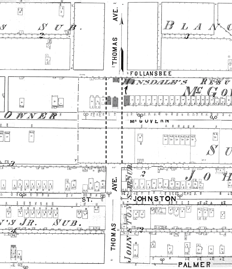
Image assembled from Rascher's Chicago Vol. 9 fire insurance maps, 1886. Library of Congress, Geography and Map Division Dotted lines added to show the current route of Sacramento (formerly Thomas) Ave. Shaded houses were moved or demolished.
The blocks along Lyndale were planned by John Johnston Jr.'s development company, while the blocks along Belden were planned by developers Edwin Hinsdale and John D. Allen. There was apparently little coordination between the developers of the two areas, resulting in a disjointed street grid.
On a modern map, it seems obvious that Sacramento was bound to be a larger throughway, as it is halfway between Kedzie and California Aves, which follow the township section lines which subdivide all of Illinois. That Hinsdale and Allen platted this corridor as private lots rather than a public street makes it appear that they were greedy to profit from every inch of their development rather than plan for how the streets might fit in to a future neighborhood.
The fire insurance map shows there were once two houses in what is now the roadway of Sacramento Ave. Both were frame workers cottages built by John Allen's development company in 1883. Laborer Carl Freitag and his wife Henrietta purchased the house on the left in that year, and milk dealer Julius Schultz and his wife Karolina purchased the house to the right of it the following year. A large barn or shed for Schultz's horses or wagons stood at the back of the lot along Follansbee.
The next house to the west of those cottages still stands. Herman & Sophia Schleek paid $1,350 for the workers cottage at 3002 W. Belden in 1883 a few months after the Freitags. Though the house has been modified and extended on the front since then, it's not too hard to imagine what it might have looked like before those changes. The lost Freitag house next to it was the same size and perhaps looked similar.
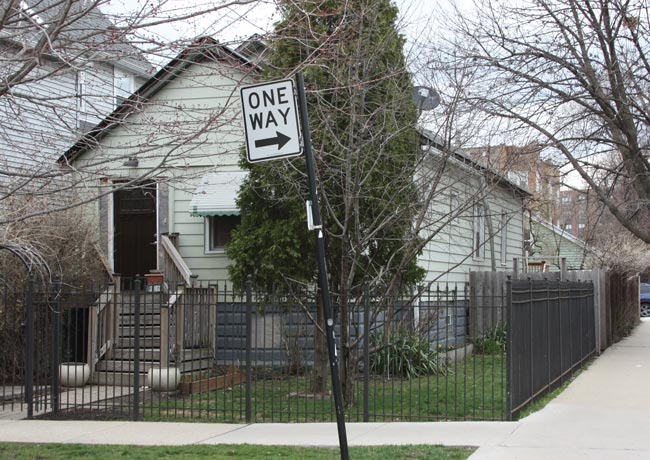
Workers cottage at 3002 W. Belden Ave, built 1883
After the area was annexed to Chicago in 1887, the disconnected street grid made even less sense. Logan Square was no longer on the fringes of the city but was becoming a dense urban neighborhood which must fit in to a logical grid of streets for traffic to travel in any direction. In March 1890 the city condemned the Freitag and Schultz houses, which were only seven years old.
The Freitag family most likely moved to a rental apartment nearby. In April 1893, Carl Freitag filed a building permit for a new wood-frame two-flat just down the block at 3028 W. Belden. Carl & Henrietta Freitag raised nine children there. After they passed away in 1921 and 1925, their children sold the property. It was demolished in 1927 and replaced by the 14-unit brick apartment building which still stands there.
Another curiosity on the map is the frame cottage that stood east of the Freitag and Schultz houses, on the edge of what is now the Sacramento Ave right of way. Owner William Russel moved this house in 1915 to the back of the lot, turned it to face Sacramento, and enlarged it into the 2-story building that stands at the corner of Medill today. Whether Russell moved the house to make way for another widening of Sacramento Ave, or simply to enlarge the building into a two-flat with rental apartments is unclear.