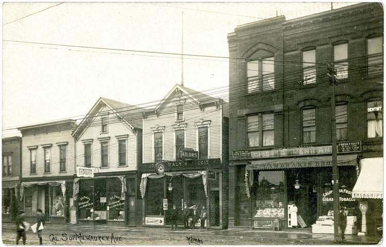
Postcard view of buildings on California Ave. between Milwaukee Ave. & Lyndale, ca. 1908. Image courtesy of Perry Casalino.
Foot traffic
The block of California Avenue north of the east end of Lyndale Street has long been a busy commercial strip. Milwaukee Avenue, just to the right of the photo above, was built in the 1850s as the North West Plank Road. This stretch of California Ave. appears on an 1869 city map, but it wasn't until the early 1880s that the properties pictured above were filled in with businesses as development sprawled north and west past the city limits at Western & Fullerton.
When houses on the surrounding streets were developed in the 1870s and 80s, commuters would have hurried by daily to catch horse-drawn trolleys on Milwaukee or simply walk past to go to work in the small factories and businesses closer to downtown. After the Metropolitan Elevated Railroad station opened in 1895 just to the left of the photo, this "transfer corner" must have seen a rapid increase in foot traffic and customers for the small shops along the street.
How many millions of feet have tromped this sidewalk since then? How many stopped in these stores on the way home from the train? How many have waited for busses and streetcars on California or Milwaukee Aves?
The modern commuter standing at the bus shelter in front of the Cozy Corner diner might recognize the right-hand building in the photo above as the one that now houses a Subway sandwich shop, but the buildings on the left were demolished in the mid 1990s.
In 1908, the busy foot traffic supported a lively street life. Though the area was far from the dense tenement districts elsewhere in Chicago, the scene looks almost cartoonishly "urban". Streetcars ran on tracks seen near newsboys hawking papers. A grocer watches over a fruit display. A penny scale sits on the sidewalk, and there is much to catch the eye and spare change of any passerby. The sidewalk was once an active outdoor community space where neighbors ran into one another.
