
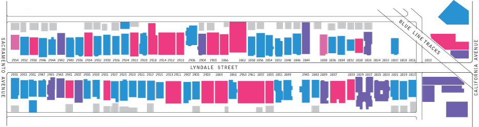
House ages on 2800-2900 Block of Lyndale
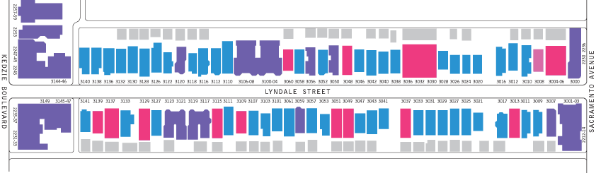
House ages on 3000-3100 Block of Lyndale
The Development of a Street
The majority of the two long blocks of Lyndale between Kedzie Boulevard and California Avenue were part of a 130-acre parcel subdivided by real estate developer John Johnston Jr. in 1881 and 1882. The westernmost end of the street was subdivided by Olaf Anderson a few years later.
Before then the story of the area is less clear. From time immemorial what we call Milwaukee Avenue was a loosely-followed trail across open prairie used by Native Americans. In the 1840s this often-muddy track was improved with wood to become the Northwest Plank Road which encouraged development of Jefferson Township outside the city.
Early Logan Square farmers hauled produce on the toll road to the market in the city. Nearby farmer Martin Kimbell harvested hay, a valuable crop to feed the tens of thousands of horses in the city, and perhaps an easy crop to grow on former prairie land. If the land under Lyndale was farmed similarly, it remained little changed for thousands of years until houses were suddenly built upon it.
In late 1881 and throughout 1882, John Johnston sold many undeveloped 25' x 100' parcels at $275, and 37' x 100' lots at $375. The first sold were at the east end of the street, closer to the newly-laid horse-drawn trolley tracks on Milwaukee Avenue which brought commuters closer into the city for work. Later on, Johnston put up speculative workers cottages on several of the lots farther west, such as at 2950 W. Lyndale, for buyers who were ready to move in immediately.
Many small workers cottages and wood frame two- and three-flat houses were built along the street in the mid to late 1880s while the land was still outside the city limits and not subject to Chicago's building codes restricting wood frame housing. After annexation to the city in 1889 a small number of wood-frame houses were still built, as well as several limestone-faced greystones at the east end of the street. A circa 1908 postcard photo shows that the street already had an architecturally-mixed look, with houses built at varying distances from the street and in differing styles and materials.
Some original purchasers bought two side-by-side lots, either to keep some greenspace alongside their new houses, or in hopes of someday developing the land into rental or resale property. Most of these empty lots were later built upon, but even today there are small bits of undeveloped former prairie remaining at 3018, 3019 and 3039.
The large buildings at the west end of Lyndale were built in 1900s and 1910s along with other apartments along Kedzie Boulevard and were often more expensive than the housing on the rest of the street. Originally these buildings were home to professional and white-collar workers and their families.
In the 1920s a real estate bubble brought a wave of teardowns throughout Logan Square. On Lyndale, wood-frame houses at 3001, 3100, 3106 were replaced by larger apartment complexes. In other places brick two-flats were fitted in the side lots between older houses.
After the stock market collapse in 1929 there was little new development on the street for over 70 years. By the time the housing demand recovered after World War II, economic forces in Chicago, as in many industrial cities, were shifting to the suburbs. After the Kennedy Expressway was completed in 1960 it was easy for many drivers to bypass the California and Fullerton exits entirely, and very few new houses or buildings were built in the neighborhood.
In the last decade a new wave of gentrification has been bringing new construction as well as demolition to the street.